


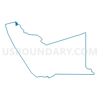
Voting District 51660, Alameda County, California
About
Outline

Summary
| Unique Area Identifier | 528690 |
| Name | Voting District 51660 |
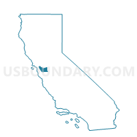
| County | Alameda County |
| State | California |
| Area (square miles) | 1.59 |
| Land Area (square miles) | 1.59 |
| Water Area (square miles) | 0.00 |
| % of Land Area | 99.91 |
| % of Water Area | 0.09 |
| Latitude of the Internal Point | 37.88859040 |
| Longtitude of the Internal Point | -122.25907320 |
Maps

Graphs
Select a template below for downloading or customizing gragh for Voting District 51660, Alameda County, California


Neighbors
Neighoring Voting District (by Name) Neighboring Voting District on the Map
- Voting District 10410, Contra Costa County, CA
- Voting District 10425, Contra Costa County, CA
- Voting District 10430, Contra Costa County, CA
- Voting District 10440, Contra Costa County, CA
- Voting District 10455, Contra Costa County, CA
- Voting District 51645, Alameda County, CA
- Voting District 51655, Alameda County, CA
- Voting District 51675, Alameda County, CA
- Voting District 51685, Alameda County, CA
- Voting District 51805, Alameda County, CA
Top 10 Neighboring County Subdivision (by Population) Neighboring County Subdivision on the Map
- Central Contra Costa CCD, Contra Costa County, CA (471,183)
- Oakland CCD, Alameda County, CA (411,480)
- West Contra Costa CCD, Contra Costa County, CA (245,523)
- Berkeley CCD, Alameda County, CA (131,119)
- Briones CCD, Contra Costa County, CA (5,375)
Top 10 Neighboring Place (by Population) Neighboring Place on the Map
Top 10 Neighboring Elementary School District (by Population) Neighboring Elementary School District on the Map
Top 10 Neighboring Secondary School District (by Population) Neighboring Secondary School District on the Map
Top 10 Neighboring Unified School District (by Population) Neighboring Unified School District on the Map
- Oakland Unified School District, CA (390,785)
- West Contra Costa Unified School District, CA (235,847)
- Berkeley Unified School District, CA (112,517)
Top 10 Neighboring State Legislative District Lower Chamber (by Population) Neighboring State Legislative District Lower Chamber on the Map
Top 10 Neighboring State Legislative District Upper Chamber (by Population) Neighboring State Legislative District Upper Chamber on the Map
Top 10 Neighboring 111th Congressional District (by Population) Neighboring 111th Congressional District on the Map
Top 10 Neighboring Census Tract (by Population) Neighboring Census Tract on the Map
- Census Tract 3560.02, Contra Costa County, CA (5,375)
- Census Tract 4225, Alameda County, CA (4,658)
- Census Tract 4224, Alameda County, CA (4,196)
- Census Tract 4215, Alameda County, CA (3,640)
- Census Tract 4212, Alameda County, CA (3,563)
- Census Tract 4216, Alameda County, CA (3,558)
- Census Tract 4217, Alameda County, CA (3,198)
- Census Tract 4001, Alameda County, CA (2,937)
- Census Tract 3920, Contra Costa County, CA (2,451)
- Census Tract 4211, Alameda County, CA (1,992)
Top 10 Neighboring 5-Digit ZIP Code Tabulation Area (by Population) Neighboring 5-Digit ZIP Code Tabulation Area on the Map
- 94704, CA (25,592)
- 94705, CA (12,762)
- 94709, CA (11,806)
- 94707, CA (11,710)
- 94708, CA (10,985)
- 94720, CA (2,964)